Background on the two authors of this article: Ken Griffith is currently researching the Neolithic Era and its implications for biblical chronology. Darrell K. White has extensively researched the ancient chroniclers and found consistency with biblical chronology. He and Ken are now converting that research into a book called The Chronological Framework of Ancient History.
Article “Candidate site for Noah’s Ark, altar, and tomb” in the latest edition of the Journal of Creation, Volume 35, issue 3, 2021.
While researching a Babel candidate site near Diyarbakir, Turkey, on 3 October 2019, they found a complex of sites on the mountain Karaca Dag that, upon further examination, seem to match the description of the landing site of Noah’s Ark, along with a tomb, possible altar, and much more. The tomb is a 60-m-square, rough stone mastaba, oriented to the winter solstice sunrise, with two extensions that make it into roughly a 160-m-long boat shape. The site is marked by six or more geoglyphs, situated along an arc 5 km distant on the northwest side of the mountain. The possible remains of the Ark appear to have had a modern school built on them, now collapsed.
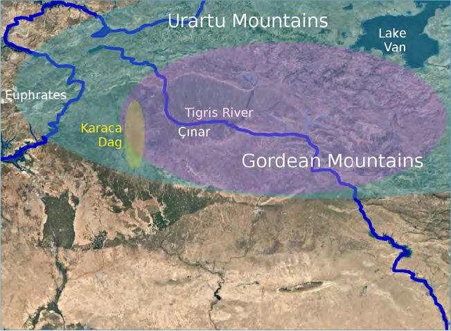
We would expect to find the landing site of the Ark near the centre of the oldest post-diluvial distribution of humans and domesticated plants. The site presented in this paper lies upon a mountain between the Tigris and Euphrates Rivers at the centre of the Pre‑Pottery Neolithic A (PPNA) Culture.
This mountain, Karaca Dag, is where the genetic ancestor of all domesticated Einkorn wheat was found by the Max Planck Institute. The other seven founder crops of the Neolithic Revolution all have this mountain near the centre of their wild range. This was so exciting that even the LA Times remarked how unusual it is that all of the early agriculture crops appear to have been domesticated in the same location:
“The researchers reported that the wheat was first cultivated near the Karacadag Mountains in southeastern Turkey, where chickpeas and bitter vetch also originated. Bread wheat—the most valuable single crop in the modern world—grapes and olives were domesticated nearby, as were sheep, pigs, goats and cattle.”
If this site is what we suspect it to be, then the Ark itself has long ago rotted away, leaving nothing but a long patch of gravel ballast and perhaps some broken pottery. Coordinates: 37°42’45.76″N 39°49’57.68″E Upon the gravel patch a school for shepherd children was built in 1928, now collapsed.
The adjacent stone tomb appears unscathed. Further away on the slopes of the mountain several geoglyphs mark the site. Two of them appear to contain writing in an unknown script.
In addition to the geoglyphs, there is evidence of ancient human habitation, farming, roads, and terraces on both ends of the mountain, 10 km north and south of the tomb and Ark site.
We will also review evidence that the site was desecrated in ancient times, making us less surprised to see recent desecrations.
Criteria
Ark searchers have claimed to find petrified wood or a frozen, intact wooden structure above the permanent snowline. Unless it landed at an elevation above 3,000 m, we expect any wood to have rotted away long ago.
Low-value imperishable materials might survive. Considering that the Ark carried a large cargo of relatively low-density foodstuff such as hay, it seems likely that it would have required ballast to ride low enough in the water. Any ballast is likely to still be there in the footprint of the vessel. We would expect to find a foreign patch of gravel, sand, or stones.
Food stores in the Ark must have been placed in rodent-resistant vessels. Therefore, we should expect to find fragments of broken vessels.
Noah built an altar nearby. Earth and stone are the only known materials for an altar for animal sacrifice (Exodus 20:24–25). The altar should have survived in some form unless it was destroyed by religious vandalism.
Extrabiblical sources inform us that Noah was buried on top of the mountain near the Ark. St Ephraim lived in both Amida (Diyarbakir) and Edessa (Sanliurfa), adjacent to Karaca Dag. He said that Noah’s tomb was near the Ark site. Hippolytus recorded the tradition that Noah brought the bones of the pre-Flood patriarchs in the Ark and reburied them after the Flood.
Other probable criteria:
- Region of ‘RRT’ (Urartu, Ararat, Aratta)
- Mashu or Masis (names of Ararat in Sumer and Armenia)
- Villages on the mountain top
- East-west axis to the site of the Tower of Babel (Genesis 11)
- Nearby tombs of Noah and/or Pre-Flood Patriarchs
Finding the right mountain
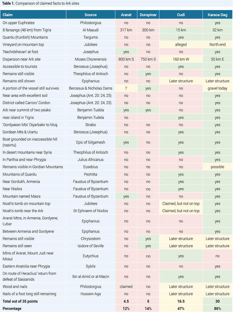
We analyzed the traditions of the church fathers, Midrash, Book of Jubilees, and other historical sources for the Ark, with gratitude to Bill Crouse who did an excellent job compiling those sources in order to justify Mt Judi as the Ark site. For this comparison, we used the following pairings of Ark and Babel sites: Ararat-Babylon, Durupinar-Babylon, Judi-Tel Brak, Karacadag-Çinar. Table 1 compares proposed Ark sites using these criteria. For each of 35 claimed facts, one point was awarded for a strong positive, one-half point for a weak positive, and zero points for a negative.